
| Operations Overview | |
| Zone | Middle Ranch area |
| Operation Window | September through October 2026 |
| Operation Hours | 90 minutes before sunset to 90 minutes after sunrise (overnights) |
| Access Status |
| LIMITED |
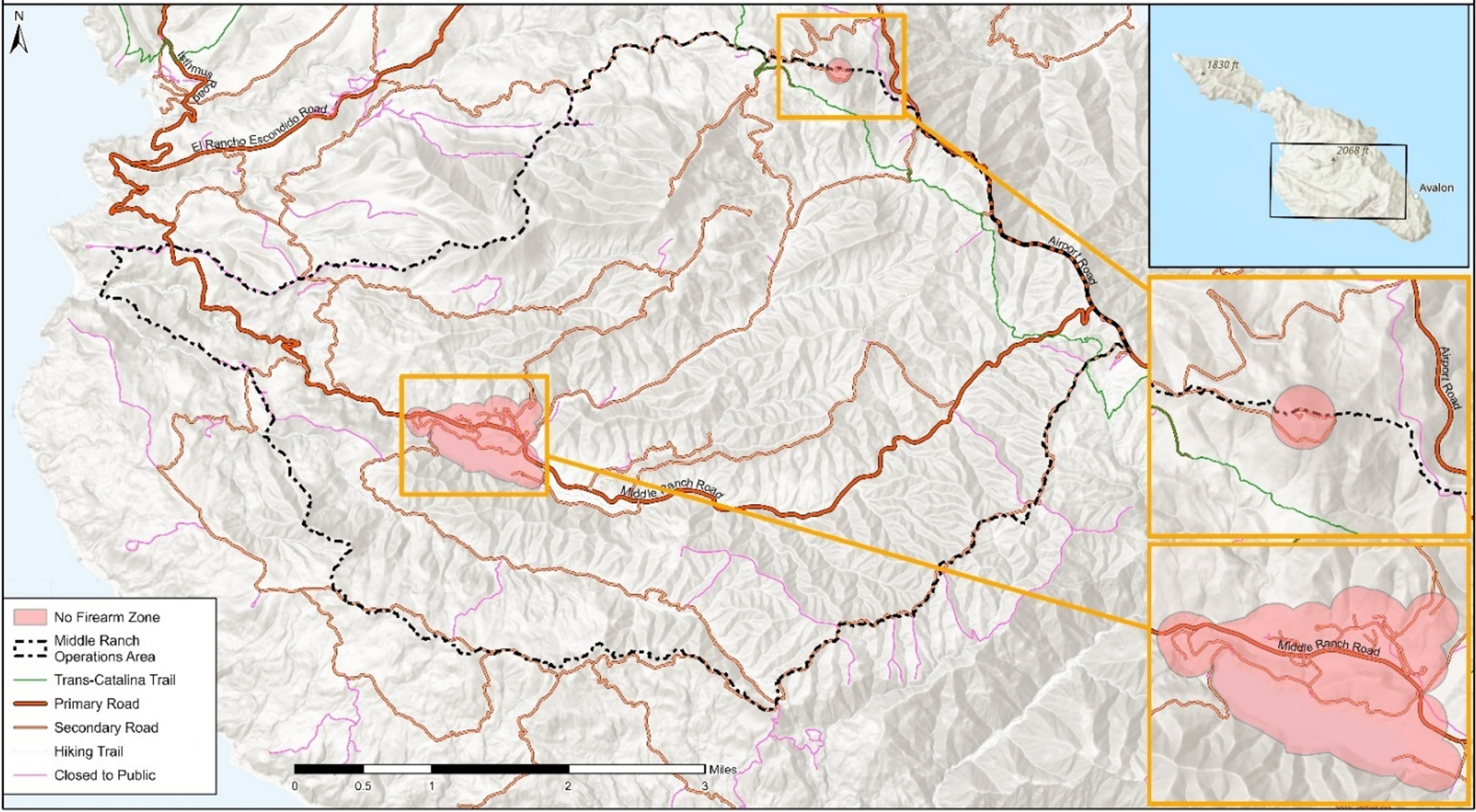
| Affected Area Middle Ranch area. See map. |
| Access Note Closed to hiking and biking after sunset
|
What is Happening
Trained wildlife management professionals will remove invasive mule deer in the Middle Ranch area as part of Operation Protect Catalina Island. The work is authorized under a permit issued by the California Department of Fish and Wildlife.
What to Expect
- Work will take place primarily during evening and overnight hours. Daytime recreation will not be impacted.
- Deer feeding stations will be set up in mid-August to prepare for operations in September.
- Hiking in the affected area will be suspended from 90 minutes before sunset to 90 minutes after sunrise, including portions of the Trans-Catalina Trail in the operations area. Hikers traveling during restricted hours should use primary roads, including Airport, El Rancho Escondido and Middle Ranch Roads, unless otherwise posted. Black Jack Campground will remain open.
- Firearms, air rifles and tranquilizers will be used by licensed professionals with extra tools to safely see deer in the dark.
- No firearms will be used within 150 yards of buildings.
- You may see field crews and vehicles working in the area.
Before You Go
- Check dates and maps before entering the area.
- Stay on open routes and respect all closures.
- Keep pets leashed.
- Do not hike or use trails in affected areas 90 minutes before sunset and 90 minutes after sunrise (overnights).
- Do not move signs, flags or temporary barriers.
- Give crews space to work safely and efficiently.
Good to Know
Mule deer are not native to Catalina. They were introduced in the late 1920s and 1930s for sport hunting, and with no predators and no ability to migrate, the population grew quickly. Decades of research on Catalina show that deer browsing keeps native plants from recovering, especially after wildfire, which allows invasive grasses to spread, prevents native habitat recovery and introduces the risk for more frequent wildfires. Learn more about this project at catalinaconservancy.org/protect.
Questions
Contact the Catalina Island Conservancy at [email protected].
Map of Operations
Operation Restrictions for Trails
90 minutes before sunset to 90 minutes after sunrise
| Date | Sunrise | Morning Restriction Ends |
Evening Restriction Begins |
Sunset |
| Sept. 1 | 6:27 a.m. | 7:57 a.m. | 5:48 p.m. | 7:18 p.m. |
| Sept. 2 | 6:28 a.m. | 7:58 a.m. | 5:46 p.m. | 7:16 p.m. |
| Sept. 3 | 6:28 a.m. | 7:58 a.m. | 5:45 p.m. | 7:15 p.m. |
| Sept. 4 | 6:29 a.m. | 7:59 a.m. | 5:44 p.m. | 7:14 p.m. |
| Sept. 5 | 6:30 a.m. | 8:00 a.m. | 5:42 p.m. | 7:12 p.m. |
| Sept. 6 | 6:30 a.m. | 8:00 a.m. | 5:41 p.m. | 7:11 p.m. |
| Sept. 7 | 6:31 a.m. | 8:01 a.m. | 5:40 p.m. | 7:10 p.m. |
| Sept. 8 | 6:32 a.m. | 8:02 a.m. | 5:38 p.m. | 7:08 p.m. |
| Sept. 9 | 6:32 a.m. | 8:02 a.m. | 5:37 p.m. | 7:07 p.m. |
| Sept. 10 | 6:33 a.m. | 8:03 a.m. | 5:36 p.m. | 7:06 p.m. |
| Sept. 11 | 6:34 a.m. | 8:04 a.m. | 5:34 p.m. | 7:04 p.m. |
| Sept. 12 | 6:34 a.m. | 8:04 a.m. | 5:33 p.m. | 7:03 p.m. |
| Sept. 13 | 6:35 a.m. | 8:05 a.m. | 5:32 p.m. | 7:02 p.m. |
| Sept. 14 | 6:36 a.m. | 8:06 a.m. | 5:30 p.m. | 7:00 p.m. |
| Sept. 15 | 6:36 a.m. | 8:06 a.m. | 5:29 p.m. | 6:59 p.m. |
| Sept. 16 | 6:37 a.m. | 8:07 a.m. | 5:27 p.m. | 6:57 p.m. |
| Sept. 17 | 6:38 a.m. | 8:08 a.m. | 5:26 p.m. | 6:56 p.m. |
| Sept. 18 | 6:38 a.m. | 8:08 a.m. | 5:25 p.m. | 6:55 p.m. |
| Sept. 19 | 6:39 a.m. | 8:09 a.m. | 5:23 p.m. | 6:53 p.m. |
| Sept. 20 | 6:40 a.m. | 8:10 a.m. | 5:22 p.m. | 6:52 p.m. |
| Sept. 21 | 6:40 a.m. | 8:10 a.m. | 5:21 p.m. | 6:51 p.m. |
| Sept. 22 | 6:41 a.m. | 8:11 a.m. | 5:19 p.m. | 6:49 p.m. |
| Sept. 23 | 6:42 a.m. | 8:12 a.m. | 5:18 p.m. | 6:48 p.m. |
| Sept. 24 | 6:42 a.m. | 8:12 a.m. | 5:16 p.m. | 6:46 p.m. |
| Sept. 25 | 6:43 a.m. | 8:13 a.m. | 5:15 p.m. | 6:45 p.m. |
| Sept. 26 | 6:44 a.m. | 8:14 a.m. | 5:14 p.m. | 6:44 p.m. |
| Sept. 27 | 6:44 a.m. | 8:14 a.m. | 5:12 p.m. | 6:42 p.m. |
| Sept. 28 | 6:45 a.m. | 8:15 a.m. | 5:11 p.m. | 6:41 p.m. |
| Sept. 29 | 6:46 a.m. | 8:16 a.m. | 5:10 p.m. | 6:40 p.m. |
| Sept. 30 | 6:47 a.m. | 8:17 a.m. | 5:08 p.m. | 6:38 p.m. |
| Oct. 1 | 6:47 a.m. | 8:17 a.m. | 5:07 p.m. | 6:37 p.m. |
| Oct. 2 | 6:48 a.m. | 8:18 a.m. | 5:06 p.m. | 6:36 p.m. |
| Oct. 3 | 6:49 a.m. | 8:19 a.m. | 5:04 p.m. | 6:34 p.m. |
| Oct. 4 | 6:49 a.m. | 8:19 a.m. | 5:03 p.m. | 6:33 p.m. |
| Oct. 5 | 6:50 a.m. | 8:20 a.m. | 5:02 p.m. | 6:32 p.m. |
| Oct. 6 | 6:51 a.m. | 8:21 a.m. | 5:00 p.m. | 6:30 p.m. |
| Oct. 7 | 6:51 a.m. | 8:21 a.m. | 4:59 p.m. | 6:29 p.m. |
| Oct. 8 | 6:52 a.m. | 8:22 a.m. | 4:58 p.m. | 6:28 p.m. |
| Oct. 9 | 6:53 a.m. | 8:23 a.m. | 4:56 p.m. | 6:26 p.m. |
| Oct. 10 | 6:54 a.m. | 8:24 a.m. | 4:55 p.m. | 6:25 p.m. |
| Oct. 11 | 6:54 a.m. | 8:24 a.m. | 4:54 p.m. | 6:24 p.m. |
| Oct. 12 | 6:55 a.m. | 8:25 a.m. | 4:53 p.m. | 6:23 p.m. |
| Oct. 13 | 6:56 a.m. | 8:26 a.m. | 4:51 p.m. | 6:21 p.m. |
| Oct. 14 | 6:57 a.m. | 8:27 a.m. | 4:50 p.m. | 6:20 p.m. |
| Oct. 15 | 6:57 a.m. | 8:27 a.m. | 4:49 p.m. | 6:19 p.m. |
| Oct. 16 | 6:58 a.m. | 8:28 a.m. | 4:48 p.m. | 6:18 p.m. |
| Oct. 17 | 6:59 a.m. | 8:29 a.m. | 4:47 p.m. | 6:17 p.m. |
| Oct. 18 | 7:00 a.m. | 8:30 a.m. | 4:45 p.m. | 6:15 p.m. |
| Oct. 19 | 7:01 a.m. | 8:31 a.m. | 4:44 p.m. | 6:14 p.m. |
| Oct. 20 | 7:01 a.m. | 8:31 a.m. | 4:43 p.m. | 6:13 p.m. |
| Oct. 21 | 7:02 a.m. | 8:32 a.m. | 4:42 p.m. | 6:12 p.m. |
| Oct. 22 | 7:03 a.m. | 8:33 a.m. | 4:41 p.m. | 6:11 p.m. |
| Oct. 23 | 7:04 a.m. | 8:34 a.m. | 4:40 p.m. | 6:10 p.m. |
| Oct. 24 | 7:05 a.m. | 8:35 a.m. | 4:39 p.m. | 6:09 p.m. |
| Oct. 25 | 7:06 a.m. | 8:36 a.m. | 4:38 p.m. | 6:08 p.m. |
| Oct. 26 | 7:06 a.m. | 8:36 a.m. | 4:37 p.m. | 6:07 p.m. |
| Oct. 27 | 7:07 a.m. | 8:37 a.m. | 4:36 p.m. | 6:06 p.m. |
| Oct. 28 | 7:08 a.m. | 8:38 a.m. | 4:35 p.m. | 6:05 p.m. |
| Oct. 29 | 7:09 a.m. | 8:39 a.m. | 4:34 p.m. | 6:04 p.m. |
| Oct. 30 | 7:10 a.m. | 8:40 a.m. | 4:33 p.m. | 6:03 p.m. |
| Oct. 31 | 7:11 a.m. | 8:41 a.m. | 4:32 p.m. | 6:02 p.m. |